Fred Knauf posted this on the FFLA New York State Chapter Facebook page
- PART 1
Happy Thursday and for many, Christmas Eve. Today’s TTT is part one of two that will close out the year, and it is fitting for a special day, as this tower has ties to the Christian faith and is about the gem of all gems of the Adirondack Mountain fire towers. Today’s TTT is about St. Regis Mountain.
John Sasso has written an excellent history of the mountain prior to it being used as a forest fire observation station, and I’m sure he will add a link to that history once this is published. He references the naming of this mountain to the River bearing the same name, which is true, but where did the River acquire that name?
Well, St. Regis was a Catholic in southern France who was born in 1597. To place this into context with the Adirondacks, this was ten years before the birth of Isaac Jogues, the first European to see Lake George. St. Regis became a Jesuit priest and spent his life teaching, assisting the marginalized, evangelizing, and assisting the poor & sick, including during the Bubonic Plague when it hit southern France. He let it be known to the order superiors that he wanted to travel to the French colonies in America along the St. Lawrence River, so that he could teach and preach to the Native Americans, but he never received those orders. His demeanor and teaching brought many over to the Catholic religion, and his death at the age of 43 in 1640 from pneumonia, brought on cries for him to be beatified in the faith, the first step to Sainthood. He was conferred as a Saint in 1737 by Pope Clement the XII. Thus, the naming of the River, and eventually the branch of the Mohawk Indians who lived near the mouth of that River, and then the mountain, all took place around 1755, as the Sasso research indicates.
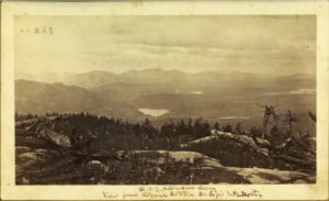
The mountain bearing the St. Regis name rises upward like a massif for those who would travel up the river and into the flat, marshy waters south-east of the present Azure Mountain. The river’s south-eastern direction in that area points directly at this mountain, so the naming is proper to the River. At 2,874 ft. it is the tallest mountain in the region, and as John’s summary details, its summit was used as a primary survey station for the Adirondack Survey. Some, but not all of the summit was cleared for that survey work, and a fire started by the survey crew in 1876 got out of hand and burned deep into the duff toppling many trees.
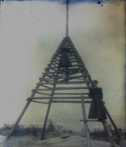
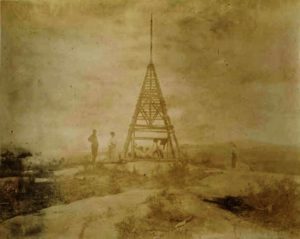
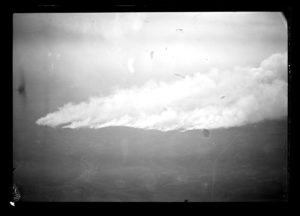
When the Adirondack Survey departed, a wooden signal tower was left atop the mountain, and another survey around the turn of the century may have used the same tower or built a newer one. In either case, neither was used as the initial fire station tower because the mountain suffered two serious forest fires that burned over the summit in 1903 and 1908, the two years of the massive forest fires in the Mountains. The fire of 1903 occurred in late May of that year and it was reported to have a 3 ½ mile wide front as it headed up the mountain. The fire in 1908 started around the 21st of October and on the 24th, Forester Pettis reported the fire at St. Regis Mountain to be “very serious”. The first was burning all around the mountain and was the worst he had ever seen. The only saving grace, if there was one, was that the fire was slowing due to running into the same areas burned over by the 1903 fire. Over 150 men were fighting the fire in 1908.
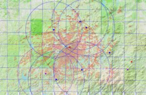
St. Regis Mountain was selected as a primary observation station in 1909 quickly after the initial station atop Mt. Morris was selected. The view span of St. Regis that would reach east to Whiteface, south & south-east to the High Peaks, west to the low-hill mountains of the north-western Adirondacks, and northward to the most northern peaks of the Mountains, meant that this summit would be an excellent sentry point for the mountains. Through this viewshed ran the Adirondack railroad from south-west to north and also towards the east as it “Y’d” at Lake Clear Junction. Toward the west, the New York & Ottawa railroad cut south from St. Regis Falls to Tupper Lake, and to the east, over near Onchiota, the Delaware & Hudson ran from Chateaugay toward Saranac Lake. As dangerous as the railroads were to starting fires, another threat was consistently present to the woods around this mountain and that was man. Paul Smith had a very popular hotel on the shore of Lower St. Regis Lake, and the entire area was favored by hunters and sportsman, much like it is today for its canoeing and kayaking. Lumbering was also occurring in the region bringing the three greatest threats for fires all together.
The fire lookout station opened in 1909 without a tall tower structure and without a telephone. The line was late in coming so the observer used mirrors to flash signals down to the Hotel when something was spotted. By the fall, however, the telephone line was strung, and all was good.
In 1910, fifty-five fires were reported from the mountain station, but one fire on Boot Bay Mountain, only 9 miles away was not reported. Haze rising from the evaporation occurring over the Lake Region and Upper Saranac Lake, were assigned the cause for not seeing this, and this issue may have led to the Conservation Commission to realize that more lookout stations were required in the regions where there were many lakes. Stations atop Arab, Ampersand and Catamount were added in the following year or two to assist the St. Regis tower.
I’ll end today in 1912 where near the end of the fire season, a 400-pound bear was taken near the summit of the mountain. The bear made no movement to run away from the hunters, and when the observer, Harry Thompson, saw the bear, he knew why because the bear had befriended him all through the year coming for scraps of food & acting almost pet-like. So, perhaps this is where the Department came up with their slogan, “a fed bear is a dead bear”.
Next week, I’ll discuss the steel tower, and the years following. Please have a safe and wonderful Christmas or other tradition Holiday. Enjoy!
PART 2
Happy New Years Eve and the final TTT, or for anyone new, Throwback Tower Thursday, for 2020. Today is part II of the St. Regis Mountain fire tower.
I will start today discussing ownership of the summit of St. Regis Mountain. The summit and the mountain’s western and northern slopes were all owned by William G. Rockefeller, one of the two brothers (John D. Rockefeller, the other) who improved oil refining and co-created the Standard Oil Corporation. By 1915, the company was split apart and the two brothers were some of the wealthiest, if not the wealthiest, men in the entire world, as the Kerosene, which they refined, had been used for home and business lighting. By 1915, they had expanded into the refinement, distribution, and sale of gasoline and business was booming – so much that the Government had forced their break-up in 1911. The lands of St. Regis Mountain were just some of William’s holdings in the St. Regis River valley that spanned along the New York Central’s Ottawa Division Railroad (renamed from the Ottawa and New York RR) from Brandon to Black Rapids Junction.
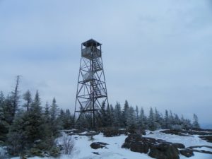
When Conservation Commission Commissioner George Pratt began the process of converting the fire observation stations over from wood to steel towers in 1916, St. Regis was not on the list. It would take another two years for the open summit station with an old wooden signal tower, at best, to be brought up to standard. In that time, agreement with the Rockefeller’s would be required to install such a permanent structure, and it is believed that the family may have actually paid for the tower for the site. The tower, one of fourteen purchased by the State for the Adirondacks that year, is believed to have been delivered by rail car to the siding at Paul Smith’s Station at Gabriels early in 1918, and from there, loaded onto wagons and delivered via wagon to Keese Mills, and then south by wagon and finally wagon/sled across Spectacle Pond to the base of the trail heading up the mountain from the shore. Teams of horses were used to haul the tower pieces up to the summit as was the case in almost all the other tower construction on the other summits. A new observer’s cabin was erected atop the mountain in 1918, and that was replaced by a 1920’s standard model cabin in 1925, both up near the summit. In 1936, about halfway down the mountain across the creek from the present trail junction with the lake trail, a newer & larger 1930’s style cabin was constructed that was similar in design to those at Azure and Poko-moonshine Mountains with the field-stone chimney.
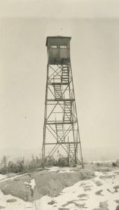
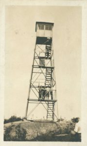
Over the St. Regis tower station’s first thirteen years, the station reported 195 fires, and in its thirteenth year, the popularity of the mountain surpassed the one-thousand visitor mark. The lowest of these years was 1918 where only one fire was reported and that may be due, in part, to the station being modernized with the installation of the new, 35-foot, LS-40 Aermotor built fire tower. I am sure that the observer at that time, Harry Thompson, enjoyed his new tower, but the end of the fire season was his last.
A new observer of fame and lore as a true Adirondack Guide took over the observer position in 1919. His name was Albert Otis. Although not as loved or lore-written about as Ampersand’s Walter Channing Rice, Albert Otis decided that, at age 62, his time as a guide was done and that he would prefer to stay put and spot for smokes. His record of reporting several fires close to their on-set, was important in keeping the forest green, and he provided vivid stories of his guide days to tower visitors. One fire that was started by a new threat in the mountains, the power line, showed his skill at spotting. In 1921, a tree fell across a power line and a fire commenced. He quickly spotted the plume, called the fire warden, Ben Muncil, who was playing golf on the Saranac Inn course at the time, and when notified, immediately went with a crew he quickly gathered and put out the fire before 1 acre was burned. Such was the speed the towers with telephones were providing. Sadly, in May of 1928, at the age of 73, Albert Otis was found dead in his rocking chair on the front porch of his observer’s cabin, pipe still in his mouth. He was found by a group of local Boy Scouts who were climbing the mountain and quickly turned back to report their sad finding.
During 1926, ownership of the summit and 3,800 acres of the northern and western slopes were purchased by the State from the William G. Rockefeller estate (who died in 1922, 5 months after his father, William Rockefeller), for approximately $ 66,800 (today’s value of $ 985,000), and which was paid from the 1916 Bond Issue funds.
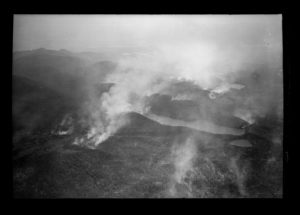
1934 was the year of the last great fire in the Adirondack Park, which started around June 3rd. The spring was so dry that Governor Lehman closed all State Lands on June 1st. The Bay Pond Fire, as it was called, pushed south-westward towards Derrick, basically along the West Branch of the St. Regis River and only 5-miles W-NW of St. Regis Mtn. The fire’s embers and smoke carried eastward with the wind and started many other hot-spot fires on the western shoulder & below St. Regis Mountain. Smoke was so dense that the St. Regis observer’s role in communicating movement of the fire was limited compared to other towers and aerial surveillance. That fire consumed a total of 10,000 acres, had over 1,500 men fighting, many from various C.C.C. camps throughout the mountains, and Conservation Department Rangers and fire fighting trucks and pumps came from as far away as Orange County and Long Island. A 25-mile fire line around the fire was completed by June 6th, and 600 men remained watching for breaks over the line while the fire went downward consuming duff, stump and root systems. In 1926, at the same date as this fire, over 2-feet of snow was reported on the north side of the St. Regis mountain.
After 1934, it seems like the climate changed in the Adirondacks, because gone was the serious large-acre fire or for that matter, serious fire threats that lasted weeks. St. Regis’ tower remained staffed and its popularity continued to grow as a wonderful hike. Even through the driest of years in ‘63 and ’64, the mountains remained relatively calm with no large-scale fires occurring.
In 1970, the St. Regis tower survived the chopping block in the “great closure”, as it became the primary tower for the new Saranac Aerial flight route that flew from the Adirondack airport and spanned the area from the northern High Peaks to Whiteface and up toward DeBar & Azure Mtns. St. Regis remained even though it was declared “non-conforming” in 1972’s Master Plan. Pressure was being applied to remove the tower, but the DEC could not find a suitable mountain to move the tower to, and the risk of fire was greatest in the area due to the many campfires used within the St. Regis Canoe area, so it remained. In 1990, when the DEC determined that aerial and fire tower surveillance were no longer needed, the St. Regis tower was closed at the end of that year’s fire season, the last of four surviving towers used that year in the Adirondack Park.
Once closed, the DEC Region 5 worked quickly to remove the lower stairs. Calls for the removal of the tower started almost as quickly and in 1987, work began on the Paul Smith’s Visitor Interpretive Center. Talk started of taking the tower down to move to the VIC in 1989 or 1990, but that work was stopped by the Office of Parks, Recreation and Historic Preservation, who put a moratorium on tower removal until a historic assessment could be made. With the surprise loss of Pharaoh Mtn tower that year, even the DEC took notice that this tower might get attacked and took extra precaution via patrolling the lot and trail a little more. Working with the OPRHP and DEC, I authored the nomination for inclusion of the St. Regis Mtn. Fire Tower into the National Historic Lookout Register, which it was accepted and certified as NHLR#117 (NY #13) on May 1, 1995. It was hoped that this registration would further turn the tide away from removal.
The tower remained on the summit, slowly declining. Paul Smith’s College began placing a summit steward on the mountain in 2000 to assist in answering questions and reduce the risk of vandalism. In 2001, Gov. Pataki authorized the DEC to begin the process of drafting the Unit Management Plan for the St. Regis Canoe area, as was requested for all other State lands. The UMP was not completed until 2006 and by that time, the DEC and OPRHP had already certified the tower on the National Register of Historic Places by the DEC, so the UMP recommended keeping the tower. In 2007, the formal restoration committee called the Friends of St. Regis Mountain was formed and their work on rehabilitating the tower is one I’d rather let them author and continues to this day. Enjoy!
